
It’s really admirable that government agencies are easier to reach now. The first agency that most of us are happy about is MMDA. Recently, when we were badly hit by a nameless monsoon, another agency stood out: DOST-Pagasa.
We saw how those two agencies helped us out fellow Filipinos through information dissemination via social media. I’m particularly happy as both MMDA & DOST-Pagasa are now embracing technology. We became more effective!
During the habagat days, I noticed tweeps following a certain @nababaha. @nababaha is the Twitter account of Professor Mahar Lagmay, a disaster scientist. Mr. Lagmay mentions Project NOAH frequently on his Twitter account. I still did not know what Project NOAH is until I got invited for a media event (organized by GetReadyPinas & #SmartActs) regarding the tool.

In this post, I’ll be sharing what I learned about Project NOAH: how it started, how it works and how we can use it effectively.
Background
Nationwide Operational Assessment of Hazards (NOAH) was launched by the Department of Science and Technology when President Noynoy Aquino instructed the agency to put in place a program for disaster prevention and mitigation.
Considering our country’s location, Philippines cannot escape typhoons, tsunamis or earthquakes. That’s why it is important for the government to implement measures so that we can prevent fatalities, infrastructure damages and economic losses due to our sensitive climate. If DOST can provide a 6 hour lead-time warning to vulnerable communities against threatening floods then it can definitely make a lot of difference.
Project NOAH’s vision is to assure homeland security by reducing casualties and property loss from extreme hazard events and build disaster resilient communities in the Philippines by way of establishing research and development platforms and the promotion of frontier science and technology in disaster efforts.
To become a world leader in programs that leverage on advanced science and technology to mitigate the impacts of natural hazards.
During the past months, NOAH integrated existing disaster science research & development projects and initiated new efforts in order to achieve its objective. Companies like Smart Communications and Digitel Mobile Philippines partnered with DOST through the NOAH program in developing systems, tools and other technologies to help prevent and mitigate disasters.
DOST will install 600 automated rain gauges and 400 water level measuring stations (river sensors) for 18 major river basins of the Philippines, namely: Marikina River Basin, Cagayan de Oro River Basin, Iligan River Basin, Agno River Basin, Pampanga River Basin, Bicol River Basin, Cagayan River Basin, Agusan River Basin, Panay River Basin, Magaswang Tubig River Basin, Jalaur River Basin, Ilog-Hilabangan River Basin, Agus River Basin, Davao River Basin, Mindanao River Basin, Tagum-Libuganon River Basin, Tagaloan River Basin and Buayan-Malungun River Basin. Other river basins will follow soon after the work on the 18 major river basins is completed.
Sensor readings from both the rain gauges and river sensors will be transmitted to the central database of DOST at least four times every hour. Information generated shall be shared to all of us through media and communication channels.
Project NOAH
We are in luck! The NOAH team has made the system available online! I heard that an Android version is on the works while there are plans to have it made for iOS and other platforms.
Here’s the site where we can access Project Nationwide Operational Assessment of Hazards (NOAH): http://noah.dost.gov.ph/.
Now that weather monitoring tools are accessible to us, we are equipped to prepare for the next disasters to come. We must embrace this development. I must admit it took some time for me to understand the system but it’s all worth it 🙂
Accessing Nationwide Operational Assessment of Hazards (NOAH)
- Get in the NOAH site by typing noah.dost.gov.ph in your browser
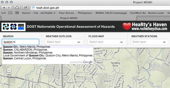
- Type in a location in the Philippines where you want to get information. For me, I typed Quezon City as I live there. You can also use the zoom feature of the Google Maps (located at the left side of the map) to get to a location.
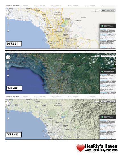
- You can choose which view you want: Street, Hybrid or Terrain. Default view is Terrain. Personally, I opt for Hybrid. It just looked so much cooler 😛 You can toggle options on the right hand corner of the map.
NOAH Features
There are a lot of information that we can get from the system. Honestly, just by going through the NOAH site made me learn a lot of things about rains and floods. I have renewed respect for the hardworking people in DOST especially PAG-ASA.
- Weather Outlook/Probability of Rain

The percent chance of rain (PCOR) is calculated every 30 minutes for all major cities of the Philippines. The forecast is done for 1, 3 and 6 hours lead time.
According to DOST, this feature isn’t only used for disaster preparedness but for farmers who want to know when to dry rice grain, fishermen who would like to check the sea condition, construction workers who need to know when to pour cement, and housebands who need to ensure fresh and sweet-smelling laundry.
This feature alone is already extremely useful and this is just one of many!
- Flood Map
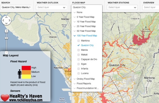
Flood maps indicate flood height and extent given a rainfall scenario. In order to understand the colors, you have to press the “legend” tab in the top right of the panel. The flood height was based on an average height of a Filipino: 5 feet and 5 inches in height. Red color means flooding greater than 1.5 meters, orange means flooding 1.0 meter high and yellow color means flooding less than or equal to 0.5 meter.
The intensity of rainfall is categorized by how often rainfall of that amount falls in a given area. Both light and heavy rains happen regularly in a certain area, but the volume of rainfall is proportional to the recurrence interval; moderate rainfall occurs every 5 years, heavy rainfall occurs every 50 years, extreme rainfall such as Ondoy occurs only every 100 years or longer.
- Weather Stations
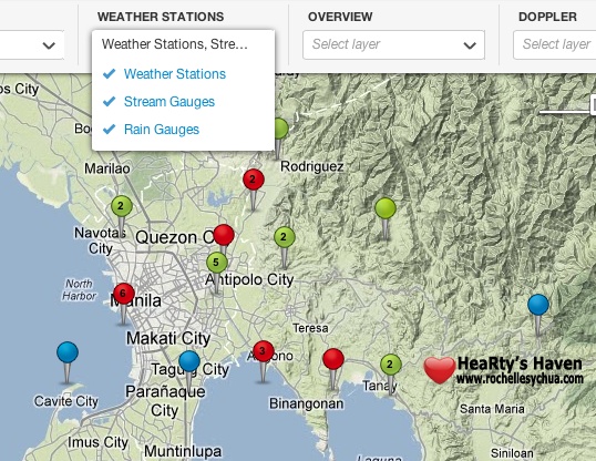
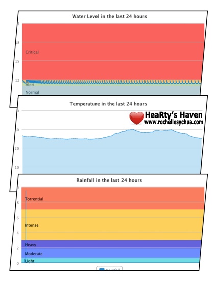
Weather stations (Temperature) show the amount of rainfall, temperature, wind speed, wind direction, air pressure, and humidity of a geographic area.
Stream gauges (Water Level) show the water level in rivers in real time. Sudden increase or unusual height of the river may indicate possible flooding.
Rain gauges (Rainfall) reflect the amount of rainfall that pours in a given area. The intensity of rainfall can be classified into light (<2.5 mm/hr), moderate (2.5<7.5 mm/hr), heavy (7.6 < 15 mm/hr), intense (15 < 30 mm/hr), or torrential rain (>30 mm/hr). They are color coded as light blue (light rain), blue (moderate rain), dark blue (heavy rain), orange (intense rain) and red (torrential rain). The amount of water collected by the rain gauges are measured in millimeters every 10, 15 or 20 minutes. The graphs that represent the measured values are in millimeters/hour.
- Overview
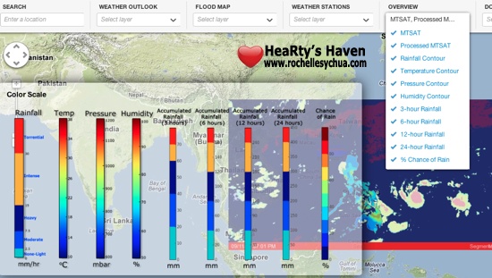
MTSAT or Multi-Functional Transport Satellite are a series of weather satellites which contain Infrared sensors which detect the extent of cloud cover, as visible from space. The images provide a view of the clouds and general weather condition of the Philippines and surrounding seas.
Rain, temperature, and pressure values are shown in different contour maps for the whole country using linear interpolation. By looking into these contour maps, you are provided with a quick look at the rain, pressure and temperature condition of every part of the Philippine land territory.
- Doppler
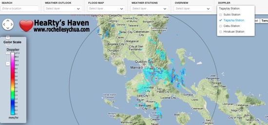
Doppler radars are configured to detect moisture or precipitation in the air and calculate its volume and movement. The different colors of the doppler image represent rainfall intensity in mm/hr and would help you determine if the rain cloud hovering your area could precipitate light, moderate, heavy, intense or torrential type of rain.
It’s rainy season again. I’m just glad that we have NOAH to refer to for weather-related information. I cannot wait for the mobile versions to come out! For now, we stick to the web to access the tool. I suggest that you follow @dost_pagasa and/or @nababaha via Twitter as well for updates.
——————–
Project NOAH
http://noah.dost.gov.ph


Leave a Reply